20May
Field Trip and Cao Bang Geotourism Plan
route 1: Hà Nội – Lạng Sơn – Cao Bằng
route2: Hà Nội – Bắc Kạn – Cao Bằng
route 3: Hà Nội – Cao Bằng
DETAILED SCHEDULE FOR ROUTE1: HÀ NỘI – LẠNG SƠN – CAO BẰNG
Day 01: Hà Nội –Lạng Sơn City –Na Dương Coal Mine –Tam Thanh and Nhị Thanh Cave – Cao Bằng
6:30: Gather from the center of Hanoi, move along the Hanoi - Lang Son highway.
7:30: Have breakfast in Bac Giang city. (estimated 30 minutes)
8:00: Continue to move to the scenic area of Tam Thanh - Nhi Thanh, Lang Son city. (estimated 1 hour 45 minutes)
9:45: Visit Tam Thanh - Nhi Thanh cave. (expected 1 hour)
|
Cave |
orientation |
Length (estimated) |
Outstanding morphological features |
|
Động Nhị Thanh |
Northwest – Southeast |
~500 m |
Water cave, with Ngoc Tuyen stream flowing through, 15-20 m high ceiling, limestone blocks, little clay, dense curtain-shaped stalactites. |
|
Động Tam Thanh |
Northeast – Southwest |
~400 m |
Dry cave, many niches; stalactites, stalagmites, stone curtains developed strongly, some ancient cave vaults have collapsed locally → proving late tectonic activity. |
10:45: Move to Lang Son City. (estimated 15 minutes)
11:00: Have lunch in Lang Son City, rest. (estimated 1 hour 30 minutes)
12:30: Move to Na Duong Lake World. (estimated 1 hour)
13:30: Arrive at Na Duong Lake World. (estimated 1.5 hours of visit)
Na Dương Coal Mine
Outstanding geological features:
One of the special geological heritage sites of Lang Son Geopark. Na Duong is an ancient sedimentary basin, where Tertiary sediment layers accumulated, especially from about 39 - 5 million years ago (Eocene - Oligocene - early Miocene). This is the largest inland brown coal basin in Vietnam, with reserves of over 100 million tons of brown coal. Sediments here include marl, mud, alluvium, small gravel, and coal layers. The depositional environments are mainly mixed aquatic - swamp - lake/lacustrine - small river (fluvial). Na Duong basin was formed as a result of sliding activity of the Cao Bang - Tien Yen fault. These tectonic activities affected the late Eocene to Oligocene, through Miocene, and still affect later. According to the survey, the total sediment thickness in the basin is about 570 m; in which the rock part of the “Na Duong formation” is about ~240 m, and the “Rinh Chua / Rhin Chua formation” is about ~300 m. At the open-pit coal mine, the upper part of the “Na Duong formation” is exposed for about 140 m. Many fossils of animals and plants have been discovered, playing an important role in paleontological research, biological evolution, and geological history of Southeast Asia.
15:00: Move to Cao Bang City (estimated 3 hours 45 minutes)
18:45: Arrive at the hotel in Cao Bang City to check in. Prepare for dinner and rest.
Day 02: Cao Bang City – Mat Than Mountain – Thang Hen Lake – Nguom Ngao Cave – Ban Gioc Waterfall – Hanoi City
6:00: have breakfast at the hotel (estimated 30 minutes)
6:30: Move to Mat Than Mountain (estimated 45 minutes)
7:15: Arrive at Mat Than Mountain for sightseeing (estimated 45 minutes)
Mắt Thần Mountain
Geological features: The God's Eye Mountain is a typical karst terrain, formed in ancient limestone from Devonian to Carboniferous (about 350–400 million years ago). The process of weathering, dissolution and collapse of underground caves lasting millions of years has created a natural round hole through the mountain body, about 50 meters in diameter, more than 50 meters high — an extremely rare phenomenon in karst geomorphology in Vietnam. This phenomenon is called karst collapse doline or “karst window” — a vivid demonstration of the karst terrain evolution process of elevation – erosion – collapse. The mountain is mainly composed of light gray to gray-white crystalline limestone, sometimes interspersed with dolomite layers, belonging to the Bac Son formation. The rock is highly solid, thickly layered, and contains many ancient marine fossils, proving that this area was once an ancient shallow seabed before being uplifted by tectonic movements. The God's Eye Mountain is a vestige of the final stage of karst topography evolution, when underground cave systems collapsed, leaving behind isolated karst domes as they are today.
8:00: Move to Thang Hen Lake and visit (estimated 45 minutes)
Thang Hen Lake
Outstanding geological features:
Thang Hen Lake is located in a closed karst valley (polje) - formed by the process of dissolution and collapse of limestone over millions of years. It is a seasonally flooded karst terrain: in the rainy season, the groundwater rises, causing the entire system of 36 small lakes in the area to connect to form a single large lake, while in the dry season it separates into many separate lakes. This rapid and strong change in water level reflects the complex underground hydrological network - a typical feature of humid tropical karst terrain. The Thang Hen Lake area is composed of thick, crystalline limestone, light gray to gray-white, belonging to the Bac Son formation, Carboniferous - Permian age (about 250-350 million years ago). In the limestone, many traces of ancient marine fossils (corals, brachiopods) appear, proving that the whole area used to be an ancient shallow sea before being raised by tectonic movements. Thang Hen Lake is a clear example of the development of an underground hydrological system in a karst landscape. The lake is fed by underground aquifers in the limestone bedrock, which connect to many caves and sinkholes. The sudden disappearance of water during the dry season in some lakes in the system — called “disappearing lakes” — indicates the existence of a complex underground drainage system.
8:45: Move to Nguom Ngao Cave (estimated 1 hour 30 minutes)
10:15: Visit the beauty of Nguom Ngao Cave (estimated 1 hour)
Nguom Ngao Cave
Outstanding geological features
The cave developed in Late Devonian to Early Carboniferous limestone (about 350–400 million years ago), belonging to the Bac Son formation – a typical limestone formation in the Northeast of Vietnam. The limestone here is of high purity, cracked and strongly weathered, favorable for the dissolution and formation of a karst cave system. Nguom Ngao Cave was formed by the process of limestone dissolution by rainwater and CO₂-rich groundwater, which took place over a very long time. Rainwater seeped down, dissolved CaCO₃ in the limestone and created a complex system of tunnels, niches, and cave floors. The entire length of the cave system is about 2,144 m, including three main areas: the main Nguom Ngao area, Nguom Ngao 1 area (Nguom Ngao Ban Gun entrance), and Nguom Ngao 2 area (Ban Thuon entrance). The complex spatial structure, with many interconnected floors and niches, demonstrates a long-term development process and is affected by both underground flows and the collapse of the limestone roof. Inside the cave, there are high arches, corridors up to tens of meters wide, interspersed with underground lakes and small active streams. The system of stalagmites, stalactites, stone curtains, stone pillars, stone towers, lotus platforms, stalactite terraces... formed by the precipitation of CaCO₃ from dripping water over tens of thousands of years. The diverse colors (white, yellow, light orange) are due to the presence of iron oxide, manganese and other secondary minerals.
11:15: Move to the restaurant around Ban Gioc waterfall area for lunch. (estimated 15 minutes) 11:30: Lunch and rest (estimated 1 hour 30 minutes)
13:00: Move to Ban Gioc waterfall and visit (estimated 2 hours)
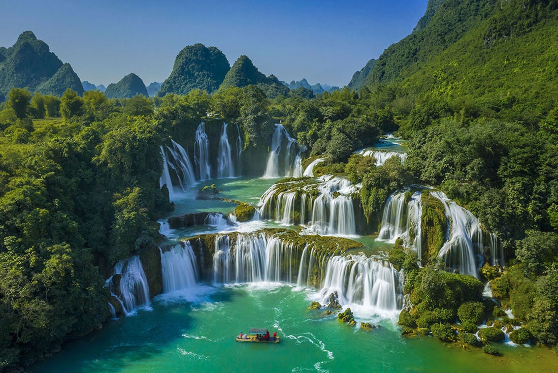
Ban Gioc Waterfall
Outstanding geological features
The waterfall area is located in the Trung Khanh - Quang Hoa fold zone, with a Northwest - Southeast direction, characterized by alternating convex and concave folds. The limestone layer is slightly inclined to the southeast, separated by small fault zones, creating conditions for the Quay Son River to cut and lower the terrain at the waterfall location. The Quay Son River flows on dissolved and fractured limestone, when encountering limestone zones of different durability, the flow begins to erode - collapse the weak rock layer, forming a waterfall step. The headward erosion gradually expands, causing the Ban Gioc waterfall today to have 3 main layers, each layer is a hard limestone step remaining after the erosion process. Secondary carbonate sediments (CaCO₃) are still precipitating at the edge of the waterfall, creating "young limestone zones" (travertine). The waterfall is located in the middle of a wide karst valley, surrounded by limestone mountains in the form of towers, columns and arches. About 30 m high, nearly 300 m wide, divided into many layers of water interspersed with lush green vegetation.
15:00: The whole group gathers on the bus to return to Hanoi.
19:00: Stop for dinner in Lang Son City
19:45: Return to Hanoi
22:45: Arrive at the city center. End of the trip.
DETAILED SCHEDULE FOR ROUTE 2: HÀ NỘI – BẮC KẠN – CAO BẰNG
*Note: The road around Ba Be Lake is small, suitable for vehicles with less than 16 seats.
Day 01: Hanoi – Ba Be Lake
6:00: Depart from Hanoi City Center, follow the Thai Nguyen – Bac Kan highway.
7:45: Have breakfast in Tan Long – Thai Nguyen area (or you can eat at Hai Dang rest stop on the highway) (estimated time for eating in 30 minutes)
8:15: Move to Hua Ma cave along the Bac Kan City – Ba Be Lake route (estimated time for 3 hours – beautiful scenery, you can stop and check in)
|
|
|
Images on the new road Bac Kan – Ba Be
Outstanding geological features
With a route length of ~60km, the entire route belongs to the Viet Bac structural zone, located in the Bac Son limestone belt, formed mainly in the Devonian - Carboniferous period (about 350-400 million years).The route passes through two main types of terrain: Non-karst lowland hills (from Bac Kan city to Don Phong commune) - mainly ancient sedimentary and metamorphic rocks. Karst limestone mountain area (from Quang Khe commune to Nam Mau commune) - typical of active tropical karst terrain.
11:15: Arrive at Hua Ma cave, visit and learn about geological elements. (estimated 1-1.5 hours)
Hua Mạ Cave
Outstanding geological features
The cave develops in light gray to gray-white crystalline limestone, sometimes interspersed with a thin layer of light dolomitization. Belonging to the Bac Son formation, of late Carboniferous - Permian age (about 250-300 million years ago). Highly pure limestone, easily dissolved by rainwater containing CO₂ → is a favorable condition for the formation of karst caves. Formed by groundwater dissolving limestone along the fault system and tectonic cracks during the long-term karstification process. The cave structure is mainly in the North - South direction, coinciding with the main tectonic development direction of the Bac Son area. The cave is located at an altitude of ~350 m, the length of the cave is ~700 m, consisting of many large, consecutive chambers with high, wide ceilings. On the cave dome and walls, there are many stalactites, stalagmites, stone curtains, stone columns with rich shapes (curtains, towers, columns, layers of precipitated stalactites in the form of waterfalls). The arrangement of stalactite layers reflects the karstification-re-precipitation cycle due to changes in groundwater levels and climate during the Holocene period. Under the cave floor there are traces of ancient underground flows - erosion channels, erosional cavities, and red-brown mud-clay sediments.
12:30: Move to Ba Be Lake area to check in at homestay. (estimated 20 minutes)
12:50: Have lunch.
14:15: Move to the boat station to visit Ba Be Lake - Ao Tien - Puong Cave - Dau Dang Waterfall. Provide interesting geological information about the area at each point. (estimated 3-3.5 hours)
Outstanding geological features :
Ba Be Lake
Ba Be Lake is the result of a combination of karstification and ancient tectonic subsidence - a rare form in Vietnam. Located in the limestone area of the Bac Son formation (Carboniferous - Permian age, ~250–300 million years), interspersed with bands of schist, siliceous rock, sandstone, and dolomite. The lake consists of 3 main branches: Pe Lam, Pe Lu, Pe Leng - separated by underground limestone ranges and peninsulas. The lake is ~8 km long, 500–1,500 m wide on average, 20–35 m deep (some places up to 35 m deep). The bottom of the lake is a layer of fine sediments including clay, silt, small sand and organic materials, accumulated over tens of thousands of years by erosion from the Nang River, Leng Stream and underground caves. Around the lake is a steep tower karst terrain, 100-200 m high limestone cliffs reflecting the classic mature karst stage.
Ao Tien
Ao Tien is actually a flooded doline (water-filled karst sinkhole). The water in the pond is very clear, blue due to light reflection through suspended CaCO₃ layers and the white limestone bed below. Around the pond are strongly dissolved karst cliffs, forming erosion channels, small domes, weathering cavities - signs of active karst processes. Under the pond floor are fine mud-clay sediments, rich in calcium minerals, accumulated from dissolved materials and deposited for a long time. This is a typical model of "hydrostatic wet karst", where groundwater - surface water - limestone interact stably. Puong Cave This is a type of crystalline limestone with blue-grey color, interspersed with dolomite, very durable, easily dissolved by rainwater containing CO₂ → creating a strongly developed karst terrain. The Nang River flows through the limestone area, encounters a system of cracks and ancient fault zones, has eroded and dissolved the limestone along weak lines, creating a natural tunnel about 300 m long, which is Puong Cave today. The cave has a high dome of 30-50 m, a width of 20-30 m, the cave ceiling has many dissolved traces, small skylights and hanging stalactites. The Nang River flows through the cave, creating a typical underground river terrain Inside there are many collapsed rocks, traces of karst collapse due to the rock roof being weakened by dissolution and gravity.
Dau Dang Waterfall
This is a light gray crystalline limestone, interspersed with layers of dolomite and thin shale, very hard and less weathered. Some sections have horizontal or slightly inclined layers of limestone, the change in hardness between these layers of rock causes the river to be stepped, creating many successive waterfalls. The waterfall is about 1 km long, divided into 3-4 large steps with each step being 5-10 m high. The water flows through the limestone blocks that are broken and collapsed, creating giant rocks interspersed with white water. Around the waterfall is a low-hill karst terrain, with many sinkholes (dolines) and steep cliffs, evidence of strong karst activity over a long period of time.
17:30: Return to the homestay to eat and rest for the early departure the next day.
Day 02: Ba Be Lake - Nguom Ngao Cave - Ban Gioc Waterfall - Hanoi City
6:00: Get up, prepare breakfast and continue the journey (estimated 30 minutes)
6:30: Continue the journey to Trung Khanh - Cao Bang. (estimated 5 hours)
11:30: Have lunch near Nguom Ngao Cave - Ban Gioc Waterfall. (estimated 1 hour 30 minutes) 13:00: Move to visit Nguom Ngao Cave. (estimated 1 hour)
Ngườm Ngao Cave
Outstanding geological features
The cave developed in Late Devonian to Early Carboniferous limestone (about 350–400 million years ago), belonging to the Bac Son formation – a typical limestone formation in the Northeast of Vietnam. The limestone here is of high purity, cracked and strongly weathered, favorable for the dissolution and formation of a karst cave system. Nguom Ngao Cave was formed by the process of limestone dissolution by rainwater and CO₂-rich groundwater, which took place over a very long time. Rainwater seeped down, dissolved CaCO₃ in the limestone and created a complex system of tunnels, niches, and cave floors. The entire length of the cave system is about 2,144 m, including three main areas: the main Nguom Ngao area, Nguom Ngao 1 area (Nguom Ngao Ban Gun entrance), and Nguom Ngao 2 area (Ban Thuon entrance). The complex spatial structure, with many interconnected floors and niches, demonstrates a long-term development process and is affected by both underground flows and the collapse of the limestone roof. Inside the cave, there are high arches, corridors up to tens of meters wide, interspersed with underground lakes and small active streams. The system of stalagmites, stalactites, stone curtains, stone pillars, stone towers, lotus platforms, stalactite terraces... formed by the precipitation of CaCO₃ from dripping water over tens of thousands of years. The diverse colors (white, yellow, light orange) are due to the presence of iron oxide, manganese and other secondary minerals.
14:00: Move to visit Ban Gioc Waterfall (estimated 1.5-2 hours)
Ban Gioc Waterfall
16:00: Gather on the bus to return to Hanoi.
20:00: Dinner in Lang Son City. (estimated 30 minutes)
20:35: return to Hanoi. (estimated 3 hours by car)
23:35: Arrive in Hanoi. End of trip.
DETAILED SCHEDULE FOR ROUTE 3: HANOI – CAO BANG
Day 01: Hanoi – Cao Bang City
6:00: Depart from Hanoi city center via Hanoi – Lang Son highway.
7:15: Have breakfast in Bac Giang city (estimated 30 minutes)
7:45: Depart for Cao Bang city. (estimated 4 hours 30 minutes)
12:15: Arrive at the hotel in Cao Bang city. Have lunch and rest. (estimated 1 hour 45 minutes)
13:45: moves to Pac Bo relic site (1 hour 15 minutes)
15:00: Visit the geological and historical values of the area such as Coc Bo Cave, Len Nin Stream, Karl Marx Mountain, Ho Chi Minh Memorial House (estimated 3 hours)
Highlights of Coc Po Cave
Coc Po Cave is formed in the limestone of the Bac Son formation, mainly composed of light gray crystalline limestone, thickly layered to blocky, interspersed with dolomite and siliceous limestone. Coc Po Cave is a lateral karst cave, formed by groundwater dissolving limestone along cracks and weak zones, then being lifted up and exposed on the mountainside. The cave opens to the West - Northwest, in a semi-elliptical dome shape, about 3-5 m wide, nearly 20 m deep, the cave is relatively flat. Inside, there are still clear traces of ancient flows and small stalactites and stalagmites, proving that the dissolution - carbonate precipitation activity has been long-term and stable. The cliffs around the cave show signs of folding and slight faulting in the Northwest - Southeast direction, showing the influence of post-Triassic tectonic phases. Coc Po Cave is located in the middle of a majestic limestone landscape, with clear blue stream water and forests, creating a typical karst picture of the Northeast mountains.
Highlights of Le Nin Stream
The entire Lenin Stream area develops on Bac Son limestone formation, mainly composed of crystalline limestone, light gray to blue gray, interspersed with dolomite layers. The limestone here is brittle and easily soluble in rainwater containing CO₂, creating conditions for the formation of underground cave systems, underground rivers and open karst flows. Le Nin Stream area is located in the Trung Khanh - Ha Quang fault zone, where there is strong uplift and fracture activity. These tectonic cracks have oriented the development of the karst hydrological network, helping groundwater to escape to the surface more easily. The exposed cross-sections on both sides of the stream show thick layered limestone, strongly fractured in the Northwest - Southeast direction, consistent with the main direction of the fault zones and folds in the area. The spring water has a characteristic clarity due to being naturally filtered through limestone layers, with few impurities, neutral pH and rich in Ca²⁺ and HCO₃⁻ ions. The stream flow shows signs of a closed karst cycle: Rain → seeps into the ground → dissolves limestone → flows in underground rivers → exposes the ground → re-dissolves rock → creates caves and karst valleys.
Highlights of Cac Mac Mountain
Cac Mac Mountain is mainly composed of light gray to blue-gray crystalline limestone, belonging to the Bac Son formation, formed in an ancient shallow marine environment in the late Paleozoic. The rock composition includes calcite and dolomite, in some places alternating layers of shale and siliceous limestone, showing fluctuations in ancient sedimentary environments. The limestone blocks have a blocky structure, thick layers, and are strongly cracked in the Northwest - Southeast and Northeast - Southwest directions. These cracks are favorable conditions for rainwater to seep in, dissolve, and form karst caves such as Coc Po cave at the foot of the mountain. It is a single karst tower mountain about 400-500 m high, with steep slopes and gentle mountain foot, often surrounded by narrow karst valleys. The mountain peak is a truncated cone (karst cone), strongly eroded and weathered, creating a rough surface, well-developed karst grooves and crevices. The Ho Chi Minh Temple at Pac Bo relic site is a cultural and spiritual work of historical significance. It is associated with a historical turning point in the Vietnamese revolution, the birthplace of important documents of the Party and the revolution, and a symbol of Uncle Ho's simple spirit and strong will.
18:00: The group returns to the hotel.
19:15: Arrive at the hotel to eat and rest.
Day 02: Cao Bang City - Mat Than Mountain - Thang Hen Lake - Nguom Ngao Cave - Ban Gioc Waterfall - Hanoi City
6:00: Breakfast at the hotel. (estimated 30 minutes)
6:30: Move to Mat Than Mountain (estimated 45 minutes)
7:15: Arrive at Mat Than Mountain for sightseeing (estimated 45 minutes)
Mắt Thần Mountain
8:00: Move to Thang Hen Lake and visit (estimated 45 minutes)
Thang Hen Lake
8:45: Move to Nguom Ngao Cave (estimated 1 hour 30 minutes)
10:15: Visit the beauty of Nguom Ngao Cave (estimated 1 hour)
Ngườm Ngao Cave
11:15: Move to the restaurant around Ban Gioc waterfall area for lunch. (estimated 15 minutes)
11:30: Lunch and rest (estimated 1 hour 30 minutes)
13:00: Move to Ban Gioc waterfall and visit (estimated 2 hours)
Bản Giốc waterfall
15:00: The whole group gathers on the bus to return to Hanoi.
19:00: Stop for dinner in Lang Son City
19:45: Get on the bus to continue returning to Hanoi
22:40: Arrive in Hanoi. End of the journey.